

|
|
Roisin and I were both tired after yesterday's long storm chase to Mullaghmore and it wasn't until 03.00 before I finally got to bed after downloading all of that days video footage and still images onto my pc and laptop before a last look at the models then shut eye. Sleep was evasive however as it was a warm muggy night and I couldn't settle myself due to the building excitement of what lay in store for Sunday's chase, I was up at 08.00, got washed and an early breakfast then fired up the laptop to once again study the forecast and make that important decision on where our target area would be. This looked to be the best chase day of the year to date so I was really buzzing with excitement but also nervous because I knew that any success would depend on good forecasting and nowcasting with smart and swift decision making while on the road. There was a very moist supply of warm air moving N on a very unstable Sly flow with strong solar heating expected with temps in the 22 degrees C range with high humidity and a trough moving N. The cold air aloft was in the -45 C range which meant fantastic lapse rates and tall cloud tops with a high chance of hail and frequent lightning.
ML CAPE values were 1300-1500 with high SB CAPE however the high resolution models indicated even stronger instability in conjunction with a lifted index between -4 and -5. Keep in mind that this is N. Ireland and values like these would be regarded as high instability so needless to say I was very excited, to tell you the truth everything looked good except for weak speed shear which meant that storms would only be slightly organised however the winds aloft were strong enough to allow some degree of updraught tilting with the prospect of multicell storms or linear/trains of storms. The Sly flow was slack which meant that any storms would be very slow moving which was good news for chasers however this could cause problems for traffic as flooding and dangerous road conditions were extremely likely as these storms would be capable of producing large amounts of precipitation which could affect one area for a long time. To be honest it looked like anywhere in Ireland and N. Ireland could get storms today however the models were greatly favoring the midlands both N and S of the border with GFS in particular showing the strongest convective precipitation readings I have seen this year smack bang in the centre of N. Ireland then again just below the border into the republic with both precip areas matching perfectly with the regions of highest CAPE and lowest LIs so there was no question in my mind that this was going to be a very active day for storms so we needed to be very sharp and focused on what we were doing. Furthermore Paul Martin from Omagh would also be chasing today too and we had already agreed that we would meet one another at some stage on the road.
I kept refreshing online resources and waited until the 10.45 GFS update which only confirmed what I already knew. ESTOFEX has issued a 50% lightning box around Ireland which was good news however I was shocked by the lack of interest from the Met Office who didn't issue a single weather warning for N. Ireland at all which I thought was crazy, I mean 1500 CAPE, LIs -5, hardly any convective inhibition or CIN (cap) and awesome lapse rates with slack motion - all of these values were screaming slow moving intense thunderstorms with high risk of flooding and bad road conditions - I was honestly shocked at this. The models also indicated areas of convergence on both sides of the border which meant that funnel clouds and brief tornadoes were also possible so this was the icing on the convective cake - and I couldn't wait to take a bite. However, unlike the previous day where I knew instinctively where to go, today I was having problems making that decision, it was not because I didn't know how to forecast but because storm potential was so widespread that I didn't know which target to choose however my instincts were trying to tell me something but I wasn't quite listening yet. To be honest my heart was in the southern target areas however my logical mind wanted to chase in the N as both areas looked just as appealing. While I was trying to decide all this we got ready to hit the road anyway as there was already 600 CAPE over the country at 09.00 and by midday there would be 1000 CAPE then the big values would peak in the late afternoon with sufficient instability lingering until 21.00 in the evening so this looked like a long day of action ahead.
Four of us would be chasing in the car today - Roisin and I, then my Mum as well as our faithful companion Rua (Cocker Spaniel dog) - who has been chasing with us on quite a few days this year. Rua loves being in the car on long road trips and isn't bothered at all by thunder, she is part of the family so there was no question of leaving her behind. We hit the road at 10.30 just as showers where crossing the border and moving N into central Ulster heading straight for us, we would be heading S and would meet them face-on so we could take a look while on the road. There's no better feeling than being out on the road and away from the computer because you will see nothing doing the latter however anything is possible when you have eyes on the sky. The sun was blocked out by clouds approaching us from the S and to be honest they looked rather shocking in appearance and much stronger than what the radar showed so we pulled off the road and parked on a hill outside Desertmartin to watch. Heavy black low level clouds (LCL was low today which was great news - that meant 100% surface based storms) sweep across the lush fields and over Slieve Gallion, they looked serious business and below was a long precip core dumping intense rainfall, I said to Roisin that that looks like a storm forming, we watched for funnels then I felt the cold downdraught of air hit us which sent me back inside for shelter.
This downdraught got me thinking that there would be numerous 'cool pooling' going on today, when a shower or storm reaches maturity it blows out an invisible pancake of rain cooled air from the precip core into the surrounding environment, these cool pools act like mini cold fronts which then lift warm moist air ahead forming new storms, this meant that there would be so many storms firing that everything could turn into a mess during late afternoon with too many storms competing with one another so it was important to get on a good storm early in the day before this happened. The cell we were watching moved N towards my home area however I let it go and continued S. My very basic plan was to head to Fermanagh then wait and make a new decision from there with the option of going N or S again however my instincts were still causing me to question this move so instead I thought it would be a wise move to just slip a little further S onto the Omagh road then rest there while getting online for a radar check and perhaps get something to eat because I had a feeling this would be a very long day with little in the way of time for luxuries.
Once we got to the S side of Cookstown I was blown away by what I saw, on view through the front windscreen was this incredible updraught exploding upward in front of us, it was so tall that I had to lean over the steering wheel and look up through the window to see the top of it, the tower was huge and rock solid with knuckles all around the tower head and sides, it looked absolutely incredible however I was on the road and couldn't get images so I kept driving S to find somewhere to pull over. I was utterly shocked by the quality of that tower, that was without question a mean looking updraught and I knew rite away that this was a real day because seeing something of that caliber before 11.00 was really something unheard of and it was obvious the atmosphere was already tapping into the CAPE and that this was just the start of it. We relocated to the Omagh Road just to the S of Cookstown and got quickly parked in a lay by then I rushed out and got a quick video clip and a few shots of the cell moving of into the distance, you can see it on the start of the video however by then it was already a good distance away with its upper regions obscured by a veil of mid level cloud.
From here on I was working on a very high state of alert, my adrenaline was pumping at the prospect of what else was in store, we then continued S along the beautiful Omagh Road surrounded by open country, green fields and vast skies, as we advanced along the road we were astonished by a row of big storms out W near the Sperrins all bathed in glorious sunshine with glistening white solid anvils arranged one after the other surrounded by blue sky and yet again I was amazed by what I was seeing, seriously this is something you would expect to see at peak heating time on the best days in Summer and not before midday, I was in heaven and I wondered if Paul Martin was seeing this amazing convection?, he would have been further S with his view blocked and I had a feeling the radar was not yet reflecting the caliber of the visual sky so he needed to know, I had no credit left on my phone (fuel is my main priority) however Roisin kindly sent Paul a text for me so I hoped we could meet up soon, however I was certain it wouldn't be long before Paul was chasing too.
I wanted to keep chasing however Roisin and Mum needed something to eat and to be honest I was in such a rush and so keenly focused that I didn't want to eat at all and most definitely didn't want to waste time and miss storms however I was out-voted and agreed to stay and eat however I was so worried that I would miss something that I decided we should eat outside so that way I could monitor the clouds. I am thankful Roisin made this decision because I was already too high on adrenaline to notice that my mind and body were tired so it was essential I got some energy because there would be a lot of hours on the road ahead so I enjoyed a beautiful lunch out in the open and even Rua was sitting on a chair eating her own lunch too which was a funny sight. I gulped everything down like a mad dog, got hydrated, then while Roisin and Mum ate their lunch at leisure I got online via the laptop to check the latest. The news confirmed that the first cell we had watched was a big thunderstorm which hit near my home with numerous c-g strikes and the big updraught we saw was a thunderstorm rite over Cookstown which we must have missed by a matter of min's, it was both amusing and ironic that the first active thunderstorm of the day was over my home in Maghera!. I had seen enough, it was obvious from this activity that the N was the place to be today so I abandoned by S idea and decided to chase in the midlands of NI instead, from experience I found that when you get cells or storms early in the day in a specific area then the chances are high that stronger storms will move into these same areas by late afternoon as long as the stream lines remained unchanged and the charts showed that they would stay S to N all day long so I was relieved which meant less driving to do, some money saved on fuel, and the great joy of chasing in my home territory. It was surreal sitting outside this restaurant on the Omagh road surrounded by ancient countryside with cells growing everywhere us.
I got in contact with Paul, he was now chasing and had relocated to a mountain to the N of Omagh. On radar and visually there seemed to be a lot of action a little further N so we decided to make a play on that for the time being so we got back on the road N and went straight to Cookstown then pulled over to the N of town on the carriageway and watched an awesome base over the fields with rotation however the area of interest soon became covered with new cloud and I lost it from view, meanwhile another cell had formed over the main road and in its vicinity was a great example of convergence with clouds moving in from different directions and meeting where the storm was located, I looked overhead and observed more rotation rite over the car, it looked like a swirling danish, it seemed like things were happening everywhere, we heard more thunder to the N, W, and soon from the S, there must have been at least three storms in our vicinity with new cells constantly developing and between these new cells were beautiful towers on the verge of forming fresh anvils, this was crazy and for a time I became overwhelmed and uncertain what to do. We changed located again and found a back road near the main and watched the bases for funnels. I have never witnessed such rapid cell development and clustering of storms since I began storm chasing as I did this day, it was amazing, exciting and extremely frustrating as I couldn't commit to any one of them, when each cell became interesting it would get covered in foreground cloud or cells would join together making a great deal of precip blocking structure, during all this time I did little in the way of photography as I was too busy driving, changing position and being indecisive, I really needed to find something more isolated or at least get on the main storm of the day, my plan was to drive S and simply pick something which looked good.
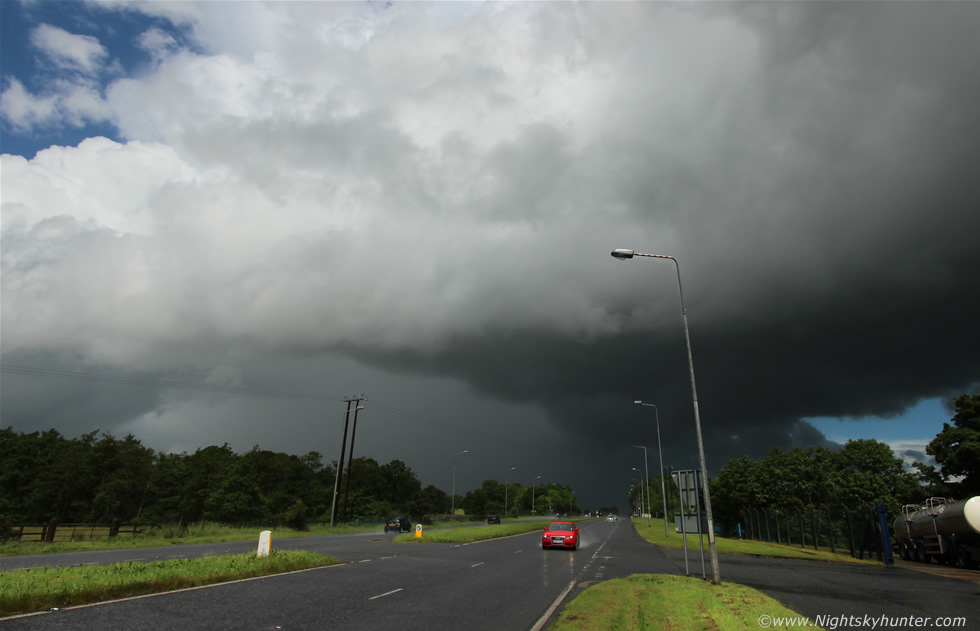 |
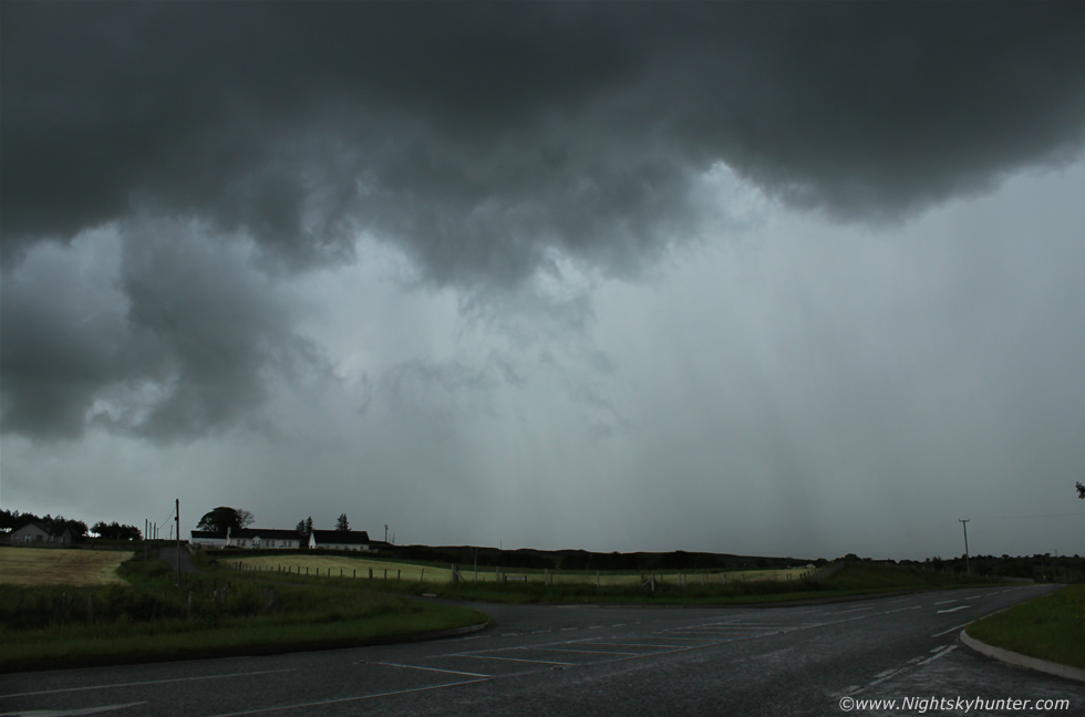
So for what seemed like the hundredth time we where once again driving S on the dual carriageway outside Cookstown when a cell came into view over the road, as we passed under it we encountered a terrific precip core which actually shocked us, small hard hail stones attacked the windows and absolutely torrential rainfall which was a thrill to drive through, visibility rapidly dropped, the wipers were going full speed and there was a constant rumbling sound from inside the car due to the noise from the rain and hail, the view out the front windscreen was impressive with a deep covering of water covering all four lanes of the dual carriageway, it almost looked like a river, the transition from sunny skies and a dry road to this in what seemed like seconds was shocking. I tried to get Roisin to take video however it was a difficult process as she was in the back seat with a restricted view and the car was unsteady so any footage used didn't work out, however from a visual stand point it was pretty cool to experience. We then punched through the core and emerged out the other side into blazing sunshine then pulled over at the edge of the road near the entrance to the milk factory and got out to shoot the storm. This was the view looking back at the storm and N down the carriageway as the storm drifted away off the road and over the adjacent fields, check out the impressive shape to the precip core, a substantial rain free base was feeding into the back of it with black tendrils of scud lifting upwards into the base exhibiting keen inflow motion and high above rock solid towers dominated the sky while the sun cooked us, the atmosphere was very warm, the sun intense and the humidity was in your face, we didn't need charts to tell us there would be storms today because we could feel it in the atmosphere all around us.
We seriously needed to get online for an update, I hadn't heard from Paul since which meant he was probably deep in action somewhere and I needed to see the bigger picture so we went back into Cookstown and parked outside ASDA so I could get wifi however for some reason I couldn't get logged on, Roisin managed to get a signal using her phone and I got a quick look at the last radar update which showed a massive crazy looking storm which had formed below the border and was in the process of heading
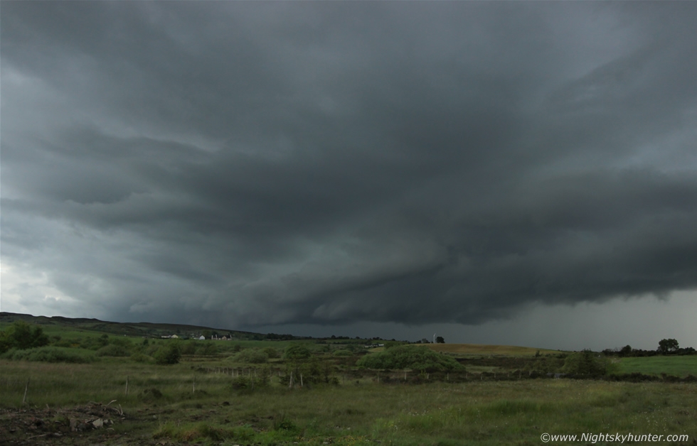
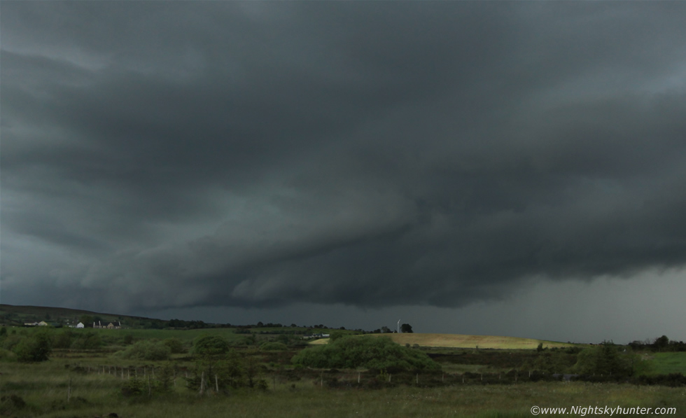
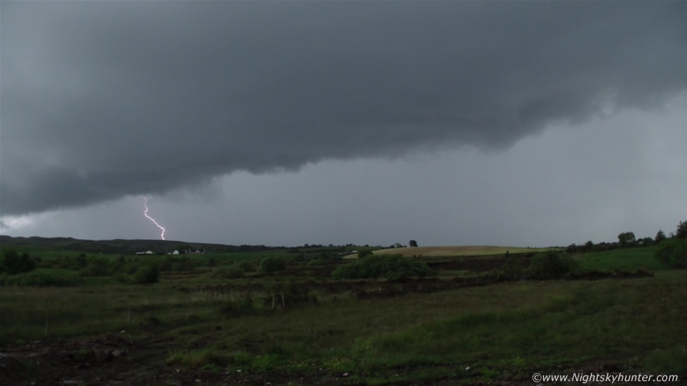
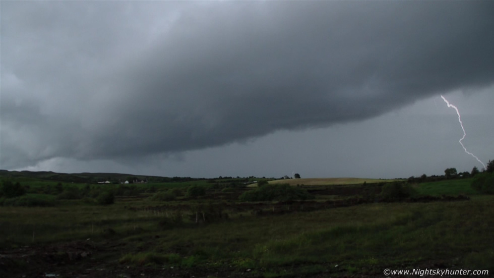
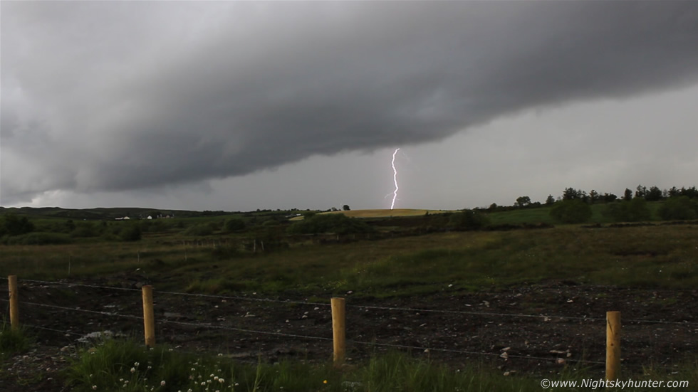
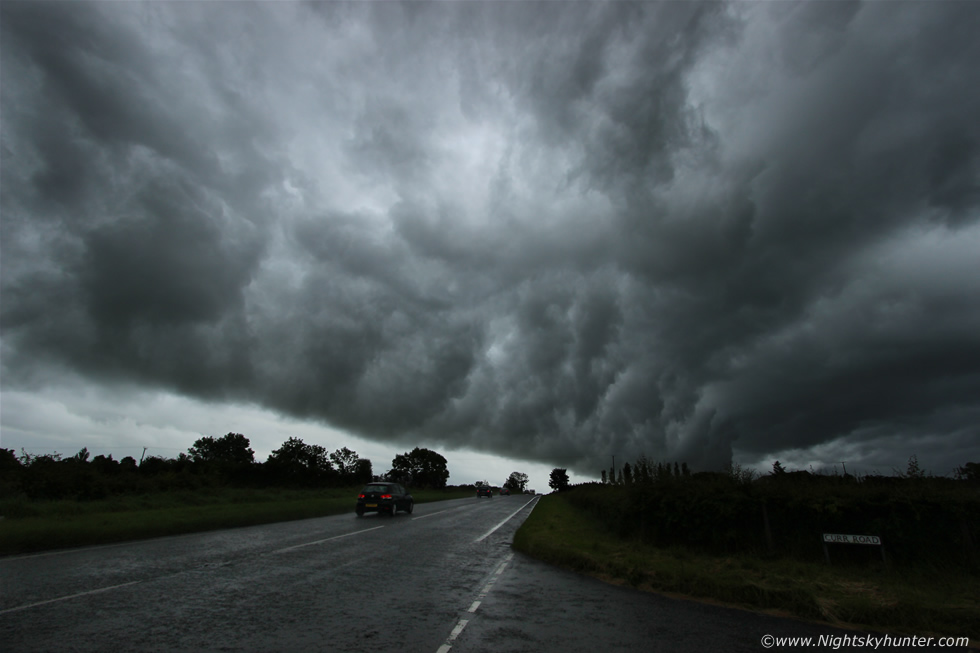
Half way between Cookstown and Omagh on the Omagh Rd we came face to face with the storm and there was no question that this was the storm of the day. It looked a menacing sight filling the windscreen with low black clouds and dark precip core taking up the entire skyline from S to NW, I mean it covered a vast area of the landscape and it looked like a nasty piece of work. I got pulled over quickly and got out for a look and saw serious lightning action with bolts randomly hitting the fields with angry thunder following, the storm was slowly heading towards us while moving N, Mum and Roisin would not leave the car as they were frightened by the lightning however I was more concerned about loosing structure as soon the heavy rain would hit it so this time we needed to move back the way we came, so we shot back N to get ahead of it this time playing cat and mouse with the storm however to be more honest we were getting chased by the storm rather than the other way around.
The idea was to keep ahead of it as long as possible to watch the developing structure and lightning for photo opps for once you let the precip get you then all photo potential is gone unless you can get away from it again swiftly and still have a decent road network to follow it. We were lucky as this big storm was moving S-N and our road was aligned S-N also so everything was flowing perfectly. We got ahead of it by a few miles once more and had time to set the video camera on the car roof and film the storm once more, half of the storm was over the fields far away to the S, the mid section was over the Omagh Rd and the N section was over the fields not far from the Sperrins. No one else would leave the car due to the lightning, pink c-gs struck down with great frequency and it was quite frightening standing out in the danger zone however it was also incredibly exciting, one cheeky bolt hit the field several hundred meters away in front of me so I got back in the car and drove N once more to get ahead and buy us some more time.
 |
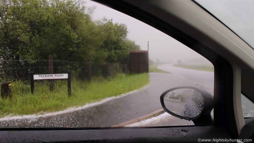
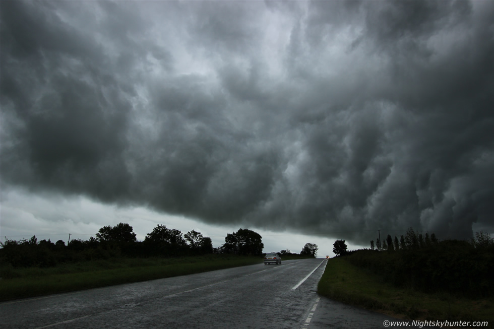
The view of the storm through the windows as we went N was impressive, Roisin got some great footage of it from the back seat as she tracked the storm side-on and for moment it was just us and storm parallel to one another as we advanced N in unison, the N side of the storm was now more active with lightning and it soon became apparent that the storm was going to beat us to the chase so we only had a short window to get images before it overtook us. I frantically scanned for a side road and eventually found a narrow back road which I had never been on before called Teebane Road, it was our only option so I took it and drove half a mile into the countryside and found a tiny opening at the side of the road and got out to document the storm. I convinced Roisin to join me and together the two of us knelt down low on the ground and watched the storm creep up on us. The N side was already out of frame to the R however the S side had now become extremely active and was the dominant sector of the line. This is the view towards the S end of the storm at 10mm, it looked like a beast and was moving straight towards us, the storm was growling with thunder and flashing deadly pink coloured bolts into the fields, Roisin and I spoke to one another in whispers as if showing the storm respect or perhaps hoping it might not hear us and strike us with a c-g.
 |
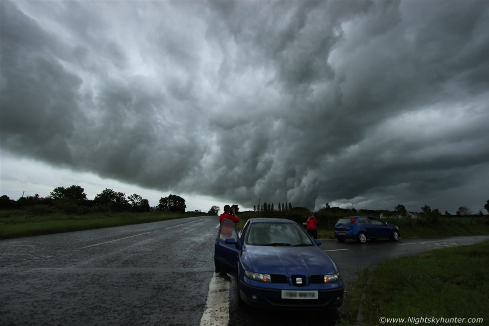
C-gs were striking the fields to the L of that distant wind mill, also to the R of it, then more far out of frame to the R too so there was a lot going on, it was hard to tell if I was nervous or excited, probably both, however Roisin admitted she was scared and Mum stayed in the car with Rua which was a good decision, we really were in a lot of danger here however we both stuck it out for as long as we could to get our shots. I was shooting stills and video with the Canon 600D while Roisin was filming with my Samsung HD video camera in the hope of catching lightning - we were very successful. The radar signature on this storm was outstanding showing a long train of individual large white echoes of very long duration, white is the top of the scale on the Met Office radar and this colour seemed to stay for the duration of multiple radar updates.
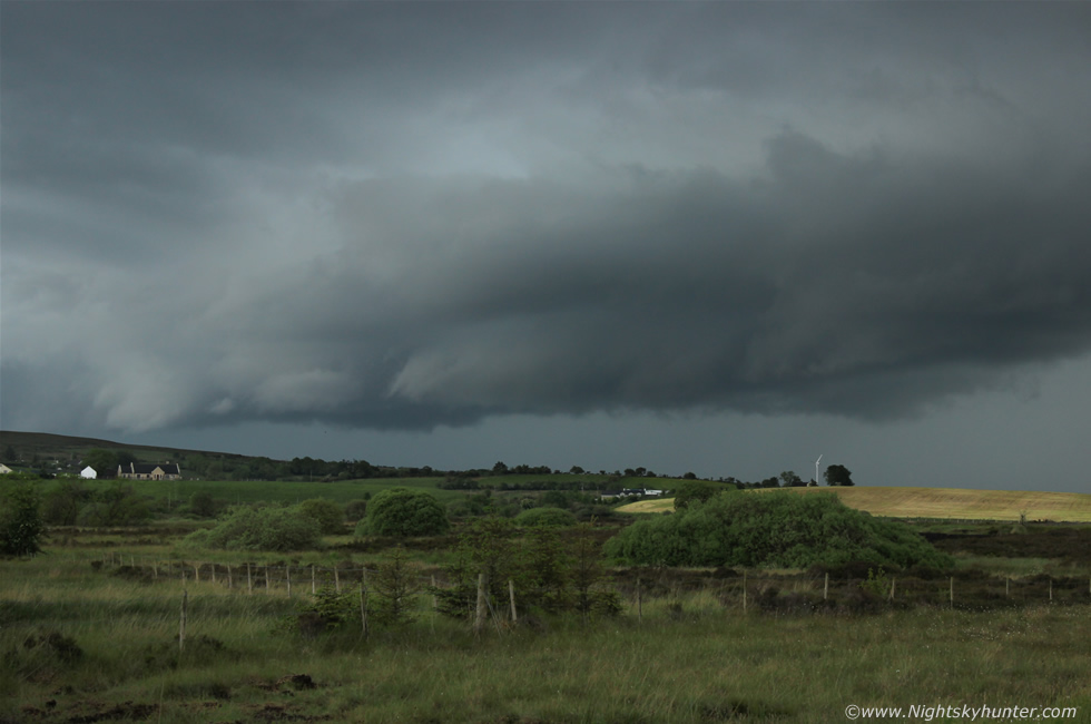 |
All three of the images above show this approaching storm with its solid shelf structure however what amazed me about this storm visually was the striking green colour to the precip core, I mean it seemed it had a beautiful green hue to it, you can hear me mentioning this to Roisin on the video. Green precip cores are usually observed in severe thunderstorms and there is still some debate over why this colour appears in storms at all with some suggesting it is the result of the play of sunlight on the precip and the refractive properties of hail (ice), however it is more well known for being a visual indictor of large hail stones, I have only seen this colour perhaps three or four times in N. Ireland and in all cases there was high precipitation or hail associated with that storm, and this storm was one of them.
 |
This was amazing to watch, three c-g bolts hit the ground one after the other in the exact same spot, you can watch this yourself on the video and I have a slowed down segment of it too, for those who think lightning never hits the same place twice watch this video, here it is doing it three times in a row!
 |
Roisin captured this crazy c-g bolt hand held - nice work Roisin - and taken under duress too, that takes guts. As you can see these bolts are pretty close and the video was set to wide angle too so they where closer than they look on the images.
 |
I got this c-g on the Canon video footage then I extracted the frame from the clip, this was 10mm ultra wide by the way, note the branching on the bolt. It was now extremely dangerous, I asked Roisin to get back in the car while I stayed out for another few min's with video camera mounted on the car roof however it got too dangerous and I had to retreat back inside.
 |
We drove back along Teebane Road then I stopped at the junction where it met the Omagh Road, put down the window, and began taking still images and video out the open driver's side window, there were close c-gs striking down and I just missed one by a second, this was taken just after the bolt struck, you can see the scud associated with the shelf cloud above and in the distance curtains of hail approaching which I didn't think anything of at the time, remember this was that green portion of the storm about to hit, the three images below are video grabs.
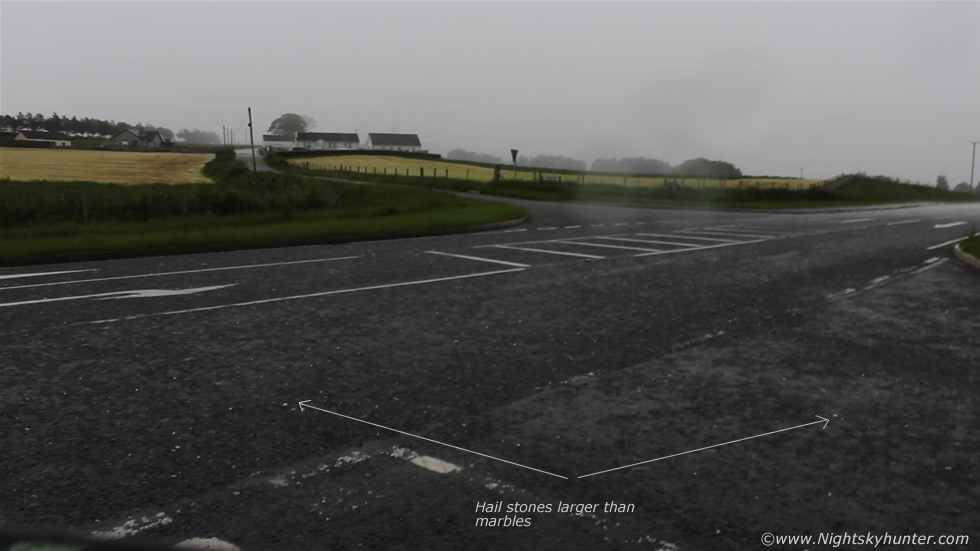 |
It was still dry and fairly calm at this point then suddenly I hear splat!! followed by a roll, then more splats, it was from hail stones hitting the road from above, at first it was frozen pea size then suddenly much larger stones began to fall. I saw marble sized stones and even bigger stones falling onto the middle of the road then suddenly a complete deluge of hail hit the car.
 |
In an instant we were experiencing the best hail storm of our lives, marble sized stones and larger members bounced off the ground and made a terrific noise as they hit the car and windscreen, I went instantly high on adrenaline loving every second of it while my Mum completely freaked out screaming while Roisin burst out laughing in the back both from the amazement of the hail and from the complete opposite reactions between Mum and I. Unfortunately Mum wanted the window up as the hail was hitting the inside of the car and she was yelling so I had to put the window up and as a result I couldn't film the hail storm properly then the windows misted over on the inside once again killing any video potential. However I will never forget the scene before the window went up, I saw what looked like large shards of glass falling from the sky onto the road, that's what the hail stones looked like as they fell through the air onto the road - shards of glass! - then the window went up, but not before one of the stones came in and hit me on the arm. I actually had a red circular mark on my skin close to the R elbow where the hail stone struck, it wasn't sore but it was stingy and I laughed when I saw it, this was the first time a storm had actually attacked me or at least left its mark on me which was a new one for the books.
 |
I managed to persuade Mum to put down the window on her side for a quick bit of filming, here you can see the smaller hail piled up on the side of the road like a layer of snow which was quite awesome to see, unfortunately I couldn't get out to photograph this or search for larger stones as the heat and humidity melted them swiftly plus I was parked at a junction to a busy road and couldn't really get out safely. The video featuring only this hail storm can be viewed here. I need to address the video though as some have been critical of it thinking I was over reacting to pea sized hail. First of all I couldn't get the larger hail on video for the reasons I mentioned and second of all when you hear me saying pea sized hail then I suddenly get excited - I am in fact reacting to the much larger hail which I could see falling from the sky onto the middle of the road, it was this which induced my excited outburst and not the pea sized hail, I didn't voice the larger hail on the video as I was awestruck by the larger stones falling so this is why the video is the way it is. I shouldn't have to explain myself however there are those who obviously need things explained, this was hands down the best hail storm I have experienced yet and remember this is unusual for N. Ireland hence the excitement. You really had to have been there to experience it, I would love to have got chatting with some of the drivers who drove through this core as I'm certain they would back up everything we experienced, the hail hit us at approximately 15.30 UT.
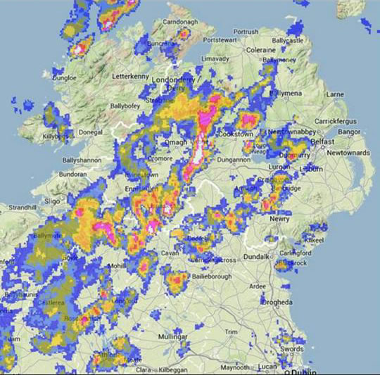 |
This is the radar which Paul captured from his mobile phone, as you can see the signature is white and the strongest in the country at the time, this white reflectivity would stay on that storm has it moved N, the white colour is where we intercepted that intense core - thanks to Paul for sending this over.
I cleared the windows then chased after it hoping to get back into the core again however the large hail component had moved over the fields and was gone however that brief encounter would never be forgotten and our own hail storm would be just one story of many to come from members of the public this day. We drove once more N on the Omagh Road while trying to get in contact with Paul, we pulled over ahead of the storm at the roadside S of Cookstown and for the first time in what seemed like hours we had a flask of tea, Paul got back to us and reported encountering deadly lightning to the S of our position, the strikes were so bad he couldn't even get out from the car so we waited while watching this portion of the storm over the fields flashing and rumbling away while I had a much needed brew. After some time Paul arrived and together we went N after the storm which was making its way over the Sperrins producing tones of lightning, it felt like we had been going non stop for hours on the road and it also seemed like we had been hearing thunder all day long which was crazy.
 |
Our two cars chased after the storm and followed it N when it was now an outflow dominant beast with bolts hitting everywhere. While outside Desertmartin we saw fantastic whale's mouth structure under the shelf cloud of the storm and I desperately wanted to shoot it before our chance was gone, Paul was in front so I sent him a mental message to pull over, a few min's later he did, Paul was thinking the very same thing as I was so we parked both cars at a junction outside the village and got shooting this massive show of whale's mouth which covered the entire sky.
 |
The above two images were at 18mm, storm moving R to L. The underside of shelf clouds can be very dramatic places for photography, the term whale's mouth can be confusing for some however it originates from the Pinocchio movie when Pinocchio is trapped inside the mouth of a whale, from what I understand the texture under the roof of the mouth is similar to the structures visible under a storm's shelf cloud.
 |
10mm ultra wide angle with the two cars and Paul and Roisin shooting the storm. It felt like we had been watching this storm forever and yet it was still producing fine c-gs with new cell development forming to the N of the line so we got back in the car and continued N to Maghera then had a brief radar check on the laptop. The latest radar update showed two more cells forming behind the big one we had chased so we left my home and went back chasing again, we dropped Mum and Rua at home so now it was Roisin, Paul and myself. I had to make a quick stop at the filling station in Maghera however the activity was mental and we had to sit for a long time before we could get away however during that time the sky was still rumbling following very active lighting activity, and I have to say at this point that I was completely used to it and enjoyed the sky light up as I filled the car with petrol.
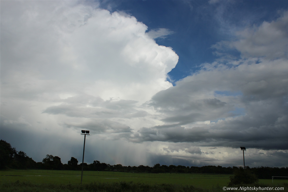 |
Roisin and I went S again and this time spotted Paul on the Tobermore Road beside the Moyola River so we parked side by side and got out to watch this new storm to our E. I set my video camera on the car roof and let it film this growing cell which you can see as a short time lapse segment at the end of the video. It was a great memory standing near the Moyola River close to home eating a snack and watching this storm explode rapidly in the distance. Images do not do this justice at all as each of us were taken back by the real time development of this updraught which formed into a rock hard anvil, it was astonishing to witness and looked more like a time lapse than reality. The above image doesn't do it justice at all, this is looking across the Moyola driving range to the E with the storm moving R to L, this storm was over Lough Neagh and was in the process of crossing into Antrim then Ballymoney region where it hit hard, the storm knocked out the power, blew electrical sockets from walls and hit the town with torrential rainfall and nasty hail. On the days following this chase I had been chatting with a business owner in Ballymoney who told me in person that he filled seven wheel barrows with hail stones from his front door!!!, the radar signature on this storm was incredible with a large white core at the top of the scale, the radar and timing all indicate that this was the storm which did it so I'm delighted to have this image and the short video clip showing it erupting to life, I also heard a second hand unconfirmed report from a man friendly with my Dad who heard about golf ball sized hail stones over Antrim from this very same cell.
We considered chasing after it however we knew that we would never make it in time as it was leaving the area however we still had one more storm behind us to deal with so we decided to get to high ground to watch for funnels, we ended up driving to near the top of Slieve Gallion bringing back memories of my first ever storm chase on the very same mountain from July 16th 2007. The drive was a hairy experience with narrow roads and soon it became evident that the storms had caused some damage due to all the rainfall, we saw a lot of large stones which had been washed down the mountain onto the roads and even a man hole cover had been blown with water bubbling out from the hole in the road. We made it to the top and watched a few distant flashes of lightning then the storms died out after 21.00 at night so we had a good chat then returned home feeling absolutely exhausted. What a brilliant chase day this was, it wasn't a photographic success for me however the visual scenes and the memories will never be forgotten which is why I wanted to document this day on the website for good. 9 and 1/2 hours chasing this day and with more storms forecast for tomorrow and the following day it was time to get prepared for day three of chasing and the anticipation of what the 22.45 GFS run will look like.
Full HD chase video filmed from the Omagh Road featuring building convection and the main Omagh Road storm with short time lapse segments and lightning followed by the hail storm, whale's mouth, then the Antrim cell at the end, thanks very much for reading.
Martin McKenna